Discover Tibet
Tibet stretches across the highest and largest plateau on Earth, a land of grasslands, great lakes and snow mountains where many of Asia’s greatest rivers are born. When Tibetans speak of their country they mean all three historic provinces, Ü-Tsang, Kham and Amdo, not only the smaller unit China calls the Tibet Autonomous Region.
Discover Tibet
Area
2.5 million km²
The Tibetan plateau, historic Tibet of the three provinces, covers about 2.5 million square kilometres. What China calls the Tibet Autonomous Region (TAR) covers less than half of it.
Average height
c. 4,500 m
Most of the plateau lies around 4,500 metres (about 14,800 ft) above sea level; Students for a Free Tibet gives an average of 14,000–16,000 ft.
Provinces
3
Ü-Tsang, Kham and Amdo, known together as Cholka-sum, ‘the three provinces’. China has divided them between the so-called TAR, Qinghai province (created from Tibetan land) and the neighbouring Chinese provinces of Sichuan, Gansu and Yunnan.
Tibetans
7 million+
China’s own 2020 census counted more than 7 million Tibetans (about 7.06 million) in the People’s Republic of China.
Great rivers
8
The Yarlung Tsangpo (Brahmaputra), Senge Khabab (Indus), Langchen Khabab (Sutlej), Mapcha Khabab (Karnali), Drichu (Yangtze), Machu (Yellow River), Dzachu (Mekong) and Gyalmo Ngulchu (Salween) all rise on the plateau.
Gaden Phodrang
1642–1959
For more than three centuries the Dalai Lamas’ government, the Gaden Phodrang, ruled Tibet from Lhasa until the occupation forced the Fourteenth Dalai Lama into exile.
Capital
Lhasa
Lhasa, ‘place of the gods’, has been Tibet’s capital since the 7th century. The Potala Palace, the Jokhang temple and the Norbulingka summer palace are a UNESCO World Heritage Site.
Lives lost
1.2 million
According to the Central Tibetan Administration, more than 1.2 million Tibetans died as a direct result of the Chinese invasion and occupation between 1949 and 1979.
Tibet Map
Tibet and its three traditional provinces: Ü-Tsang, Kham and Amdo. Tibetans call their homeland Bö, and its poets call it the Land of Snows. Ringed by the Himalaya to the south and the Kunlun to the north, the plateau holds high steppe, deep forested gorges and the largest store of ice outside the polar regions, which is why scientists call it the Third Pole.
Ü-Tsang དབུས་གཙང་
Central and western Tibet, the historic heart of the Dalai Lamas’ government. It holds the Yarlung valley, cradle of the Tibetan kings, along with Lake Namtso and the sacred mountain Gang Rinpoche (Mount Kailash).
Most of Ü-Tsang lies in what China calls the Tibet Autonomous Region (TAR).
Kham ཁམས་
Eastern Tibet, a land of high ridges cut by the parallel gorges of the Drichu (Yangtze), Dzachu (Mekong) and Gyalmo Ngulchu (Salween). Khampas are known for their trading traditions, horsemanship and resistance to the invasion.
Split by China between the eastern part of the so-called TAR (Chamdo and part of Nyingtri), Sichuan (Karze, Ch. Ganzi, Tibetan Autonomous Prefecture), Qinghai (Kyegudo, Ch. Yushu, Tibetan Autonomous Prefecture) and Yunnan (Dechen, Ch. Diqing, Tibetan Autonomous Prefecture).
Amdo ཨ་མདོ་
North-eastern Tibet, with wide grasslands around Tso Ngonpo (Ch. Qinghai Lake) and the upper Machu (Yellow River). It is the birthplace of Tsongkhapa and of the Fourteenth Dalai Lama, and home to great monasteries such as Kumbum and Labrang.
Mostly placed by China in Qinghai province, with parts in Gansu (Kanlho, Ch. Gannan, Tibetan Autonomous Prefecture) and Sichuan (Ngaba Tibetan and Qiang Autonomous Prefecture).
One Tibet, divided on the map
When Tibetans say Tibet, they mean all three provinces. When Beijing says ‘Tibet’, or now ‘Xizang’, it means only the so-called Tibet Autonomous Region it created in 1965, less than half of the plateau. The rest of Tibet was carved into Tibetan ‘autonomous’ prefectures and counties of Qinghai, Sichuan, Gansu and Yunnan. More than half of all Tibetans live outside the so-called TAR, so any figure for ‘Tibet’ depends on whose map is used. V-TAG uses Tibet for the whole country.
Chomolungma (Mount Everest)
At 8,848.86 metres, the height agreed by China and Nepal in 2020, Chomolungma stands on the border between Tibet and Nepal.
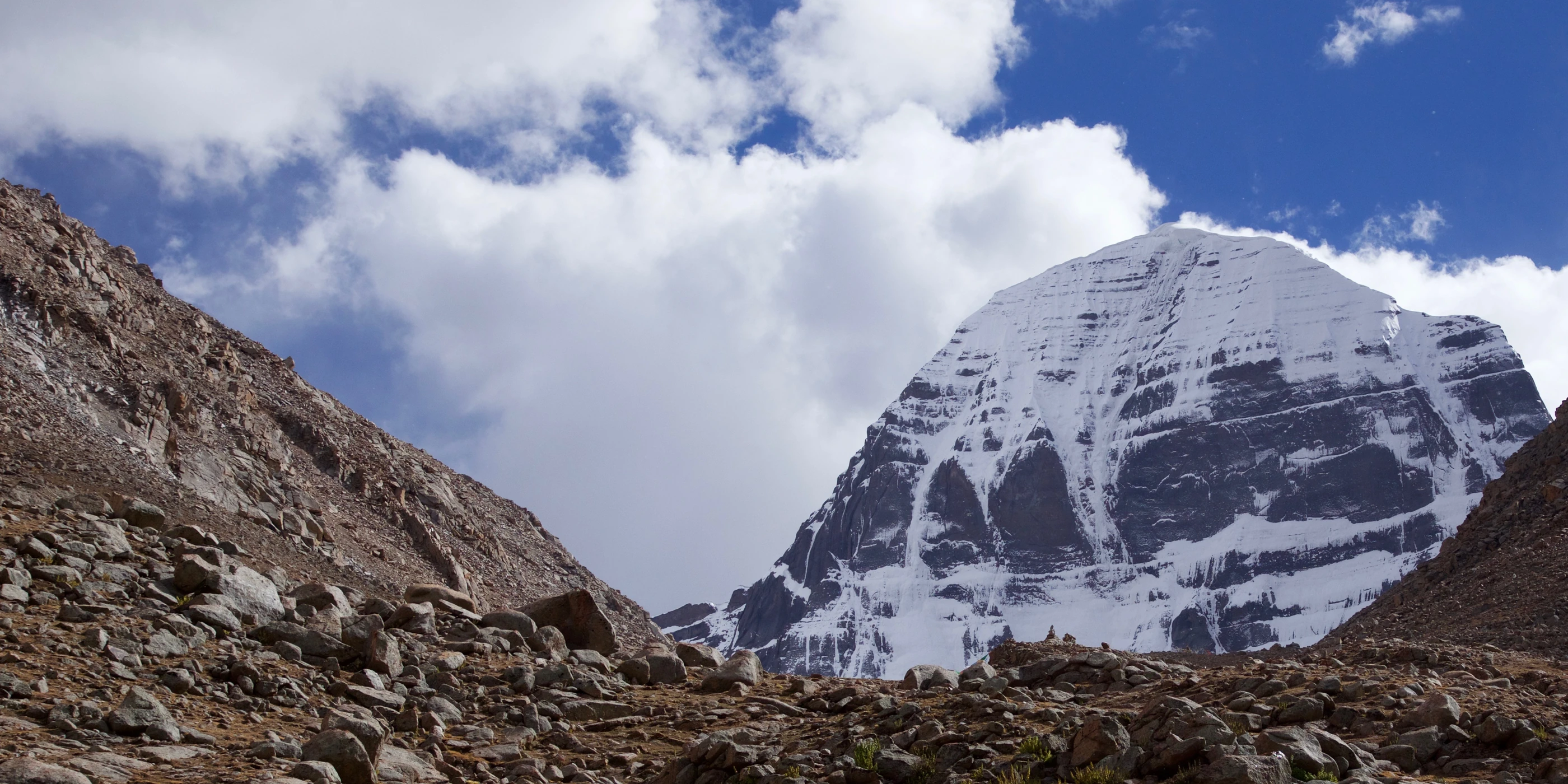
Gang Rinpoche (Mount Kailash)
The ‘precious snow mountain’ of western Tibet is a place of pilgrimage for Buddhists, Bonpos, Hindus and Jains.
Mapham Yumtso (Lake Manasarovar)
The sacred lake below Gang Rinpoche, close to the sources of four great rivers.
Namtso
The great lake of the Changtang, the high northern steppe, north of Lhasa.
Yamdrok Tso
A turquoise lake south of Lhasa, held sacred by Tibetans.
Tso Ngonpo (Ch. Qinghai Lake)
The ‘blue lake’ of Amdo, the largest lake on the plateau.
Shishapangma
The only peak above 8,000 metres that lies wholly inside Tibet, north of the Nepal border; published heights range from 8,012 to 8,027 metres.
Namcha Barwa
The great peak at the eastern end of the Himalaya, standing inside the bend where the Yarlung Tsangpo turns south towards India.
Nyenchen Tanglha
A 7,162-metre peak above Namtso, north of Lhasa, revered as a mountain deity.
Amnye Machen
The sacred mountain of Golog in Amdo, home of the protector Machen Pomra and the focus of a great pilgrimage circuit.
Siling Tso
A salt lake in the Changtang that has grown since the 1970s to become the largest lake in the so-called TAR.
Dzoge (Ch. Ruoergai) wetlands
The largest high-altitude marsh in the world, on the border of Amdo and Kham, partly drained for pasture in the 1970s.
The roof of the world
The Tibetan Plateau is the highest and largest plateau on Earth. The Central Tibetan Administration gives the area of Tibet, all three provinces together, as 2.5 million square kilometres, at an average altitude of about 4,000 metres. The plateau was lifted by the collision of the Indian and Eurasian plates, the same collision that still pushes the Himalaya upwards, and it holds high steppe in the north and west and deep, forested river gorges in the south-east.
Ü-Tsang, Kham and Amdo on today's map
Tibetans speak of their country as Cholka Sum, the three provinces: Ü-Tsang in the centre and west, Kham in the east and Amdo in the north-east. After the invasion, Chinese authorities redrew the map. Most of Ü-Tsang and western Kham became the so-called Tibet Autonomous Region in 1965, today divided into seven prefecture-level units: Lhasa, Shigatse, Lhoka (Ch. Shannan), Nyingtri (Ch. Nyingchi), Chamdo, Nagchu (Ch. Nagqu) and Ngari. According to the CTA, the rest of Tibet lies in Qinghai province, in two Tibetan autonomous prefectures and one Tibetan autonomous county of Sichuan, one prefecture and one county of Gansu, and one prefecture of Yunnan. These include Tsojang (Ch. Haibei), Tsolho (Ch. Hainan), Malho (Ch. Huangnan), Golog (Ch. Guoluo), Yulshul (Ch. Yushu) and Tsonub (Ch. Haixi, shared with Mongols) in Qinghai; Karze (Ch. Ganzi), Ngaba (Ch. Aba) and Mili (Ch. Muli) in Sichuan; Kanlho (Ch. Gannan) and Pari (Ch. Tianzhu) in Gansu; and Dechen (Ch. Diqing) in Yunnan. The traditional provinces describe one people and one country; the administrative units describe how the occupation governs it.
Mountain ranges
Tibet is walled and crossed by great ranges. The Himalaya runs along the southern border and the Kunlun along the northern edge of the plateau. The Tanggula (Tibetan: Dangla) crosses the centre and holds the sources of the Drichu (Yangtze). North of the Yarlung Tsangpo, the Transhimalaya runs parallel to the Himalaya: its western part, the Gangdise or Kailas Range, holds Gang Rinpoche, and its eastern part is the Nyenchen Tanglha. In Kham the Hengduan mountains form parallel north-south ridges cut by the gorges of the Drichu, Dzachu (Mekong) and Gyalmo Ngulchu (Salween), and in Amdo the Amnye Machen range extends the Kunlun eastwards.
Great peaks
Besides Chomolungma, Tibet holds Shishapangma, the only peak above 8,000 metres that stands wholly inside Tibet; Britannica gives its height as 8,012 metres, while other surveys give 8,027 metres. Namcha Barwa, inside the great bend of the Yarlung Tsangpo, anchors the eastern end of the Himalaya at 7,756 metres according to Britannica (other sources give 7,782 metres). Gang Rinpoche (Mount Kailash) rises to 6,714 metres according to Britannica, though 6,638 metres is also widely published. Nyenchen Tanglha, north of Lhasa, reaches 7,162 metres, and Amnye Machen in Golog, about 6,282 metres, is revered as the home of Machen Pomra, the chief protector deity of Amdo.
Glaciers
The CTA's Environment and Development Desk writes that the plateau and its surrounding mountains hold more than 45,000 glaciers covering about 105,000 square kilometres, the largest mass of ice outside the polar regions. Scientists led by Yao Tandong found in 2012 that glaciers were shrinking most in the Himalaya, while some glaciers in the north-west were stable or advancing. Glaciers on Chomolungma, Shishapangma and Namcha Barwa, and the Chemayungdung glacier at the source of the Yarlung Tsangpo, feed the rivers that leave Tibet.
Lakes
Tibet is a land of lakes, many of them salt lakes with no outlet. Namtso lies at about 4,700 metres in the Changtang, and Siling Tso, north of it, has grown so fast that it is now the largest lake in the so-called TAR: a 2024 study by Wang and colleagues measured its area at 1,647 square kilometres in 1972 and 2,439 square kilometres in 2020. Tso Ngonpo (Ch. Qinghai Lake) in Amdo is the largest lake on the plateau. Yamdrok Tso, sacred to Tibetans, feeds a hydropower station whose construction the Tenth Panchen Lama opposed; work was halted in 1986 before Chinese authorities resumed it. Mapham Yumtso lies below Gang Rinpoche.
Wetlands
High wetlands store water and carbon and are breeding grounds for black-necked cranes and other birds. The largest is the Dzoge (Ch. Ruoergai or Zoige) marsh on the border of Amdo and Kham, the largest high-altitude marsh in the world. In the 1970s it was ditched and drained to create pasture: a 2018 study by Li and colleagues found that about 52 per cent of its original 4,600 square kilometres of surface peat had turned to grassland. Other sources give the marsh area as about 2,600 square kilometres, depending on how it is measured.
Grasslands and the Changtang
Grassland covers most of Tibet. In the north lies the Changtang, the high, cold steppe of the nomads and the wild herds. Further east, mats of the small sedge Kobresia pygmaea cover about 450,000 square kilometres, which Miehe and colleagues describe as the world's largest pastoral alpine ecosystem, grazed by Tibetans and their yaks for thousands of years. How far the grasslands have degraded, and why, is disputed: a 2010 review by Richard Harris found too little evidence to prove any single cause, yet Chinese authorities have used 'degradation' to justify fencing pastures and removing herders, which Human Rights Watch has documented.
Valleys and forests
Most Tibetans who farm live in the valleys of the south and east. The Yarlung valley, the Kyichu valley around Lhasa and the Nyangchu valley of Gyantse and Shigatse grow barley and other crops. In the south-east the Yarlung Tsangpo cuts one of the deepest gorges on Earth around Namcha Barwa, falling about 2,000 metres in some 50 kilometres according to Chinese engineering figures, and in Kham the Drichu, Dzachu and Gyalmo Ngulchu run side by side through the Three Parallel Rivers area that UNESCO lists as a World Heritage site. These warmer gorges hold Tibet's forests of fir, spruce, pine, oak and rhododendron.
Climate
Tibet's climate is high, cold and dry, with strong sun and long winters. The summer monsoon brings rain to the forested south-east, while the Changtang in the north-west receives little. The plateau is warming fast: Yao and colleagues report that the Third Pole is in its warmest period of the past 2,000 years. Published warming rates are around 0.3 °C per decade, which some reports describe as twice the global rate and others as up to three times.
The water tower of Asia
The CTA calls Tibet the Third Pole and the water tower of Asia. Its major rivers include the Yarlung Tsangpo (Brahmaputra), Senge Khabab (Indus), Phungchu (Arun), Machu (Yellow River), Drichu (Yangtze), Gyalmo Ngulchu (Salween) and Dzachu (Mekong), which flow to South, Southeast and East Asia. The CTA writes that about 1.3 billion people depend directly on these rivers; ICIMOD estimates that some 1.65 billion people live downstream of the wider Hindu Kush Himalaya. A 2020 study in Nature ranked the Indus, which rises in western Tibet, as the most important and one of the most vulnerable mountain water towers in the world.
A land under strain
Zou and colleagues mapped permafrost under about 1.06 million square kilometres, some 40 per cent of the plateau, and the IPCC reports that mountain permafrost is warming and thawing. Lakes are growing as ice and frozen ground melt, flooding pastures, while glaciers shrink. On top of these changes come dams, mines, roads and the removal of nomads from the land, decided by Chinese authorities without the free consent of the Tibetans who live there. What happens to Tibet's ice, water and grassland affects water security for much of Asia.